Where to Catch Scenic Views of Lowell
Lowell is a city with unique historic and contemporary features. Located on the Merrimack River, the city developed as an industrial center in the nineteenth century and many of the mills and canals that were built over the years are still standing today.
Lowell's combination of natural and built environments creates dramatic vistas throughout the city. Sightseers have many vantage points from which to survey the city. This is a sampler of these vantage points for viewing the city, whether for an Instagram post, personal observation or as part of an activity.

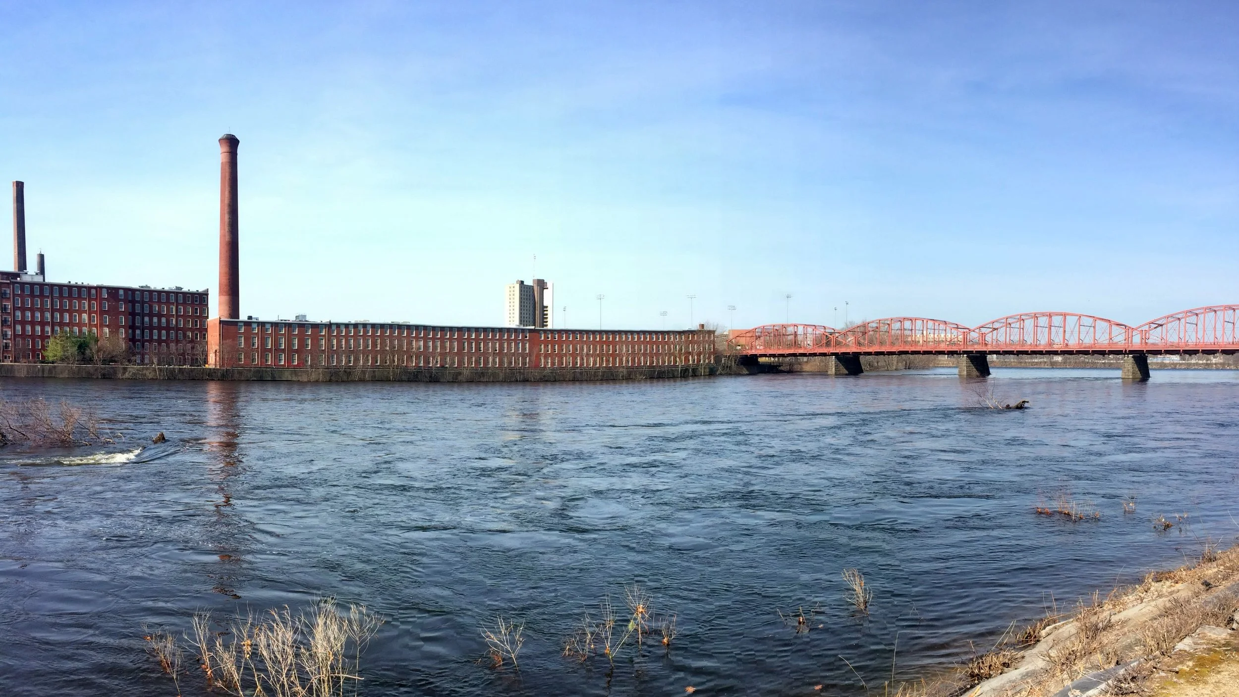
1. Merrimack River Behind LeLacheur Park
LeLacheur Park is home to the Lowell Spinners, the Class-A, short season affiliate of the Boston Red Sox, as well as the UMass Lowell River Hawks baseball team. Behind the stadium is a riverwalk extending through UMass Lowell's East Campus. The trees obscure this particular view slightly until a clearing opens up and a sandy beach is revealed.
This beach offers a view of the Merrimack River at its widest point in Lowell. Looking across is a view of both Pawtucketville (to the west/southwest) and Centralville (to the east/northeast). The river at this beach is a torrent in the spring but calm in the summer. Also, Beaver Brook empties into the Merrimack directly across the river. This is a great spot to watch for bald eagles perched in nearby trees! Lowell has many great views of the Merrimack and this location is a gem.

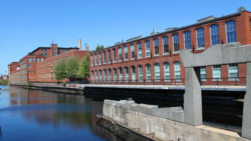
2. Canal near UMass Lowell's Fox Hall
Amateur and professional photographers alike appreciate a beautiful sunset, especially when it creates a mesmerizing, peaceful reflection on water. The view of the northern canal, located between UMass Lowell's East Campus and Father Morissette Boulevard, offers stunning scenes. The canal extends from Pawtucket Street to Suffolk Street and a walk along the canal-bordering path provides great opportunities for sunrise to sunset pictures.

3. Inside Mill No. 5
This view isn't as much of a "view" as it is a historical vista. Mill No. 5 is a collection of distinctive small businesses located in a Jackson Street mill built in 1873. Once the elevator doors open into the fourth floor, Mill 5 presents a metaphor of the city itself and is just waiting to be photographed.
Preserved, nineteenth-century architecture and modern renovations combine with the flair and personality of small businesses to create something truly special. There are many eye-catching features along the central hall's creaky wood floor. Visitors are in for a unique shopping experience when they visit the mill.
4. Merrimack River Bike Path
The river bike path is located at the southernmost point of the Centralville neighborhood, running just below the VFW Highway. The path, in addition to being a great place to walk, jog, and observe wildlife such as waterfowl and beavers, offers beautiful views of both the Merrimack and Concord Rivers. The Concord River is no tiny tributary; it flows north from Wayland to Lowell where it empties into the Merrimack.
The path is the best location in Lowell to view the confluence of the two rivers, providing plenty of changing water and "Mile of Mill" views.

5. Concord River at Muldoon Park
Muldoon Park, located in the South Lowell neighborhood near Lawrence Street, features a landing on the Concord River. This is the perfect place to relax, take photos, fish or launch a boat.
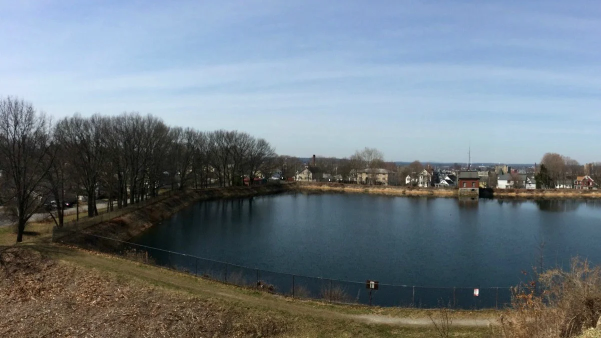
6. Christian Hill Resrvoir
The Christian Hill Reservoir in Centralville has one of the highest natural points in the city. The lack of bright lights surrounding the elevated reservoir makes this a great destination for stargazing.
Viewing the horizon offers incredible sights across the entire city below. On clear days, New Hampshire and its mountain ranges can be seen! This location is not only the top of the city but is also the top of any list for sightseers.

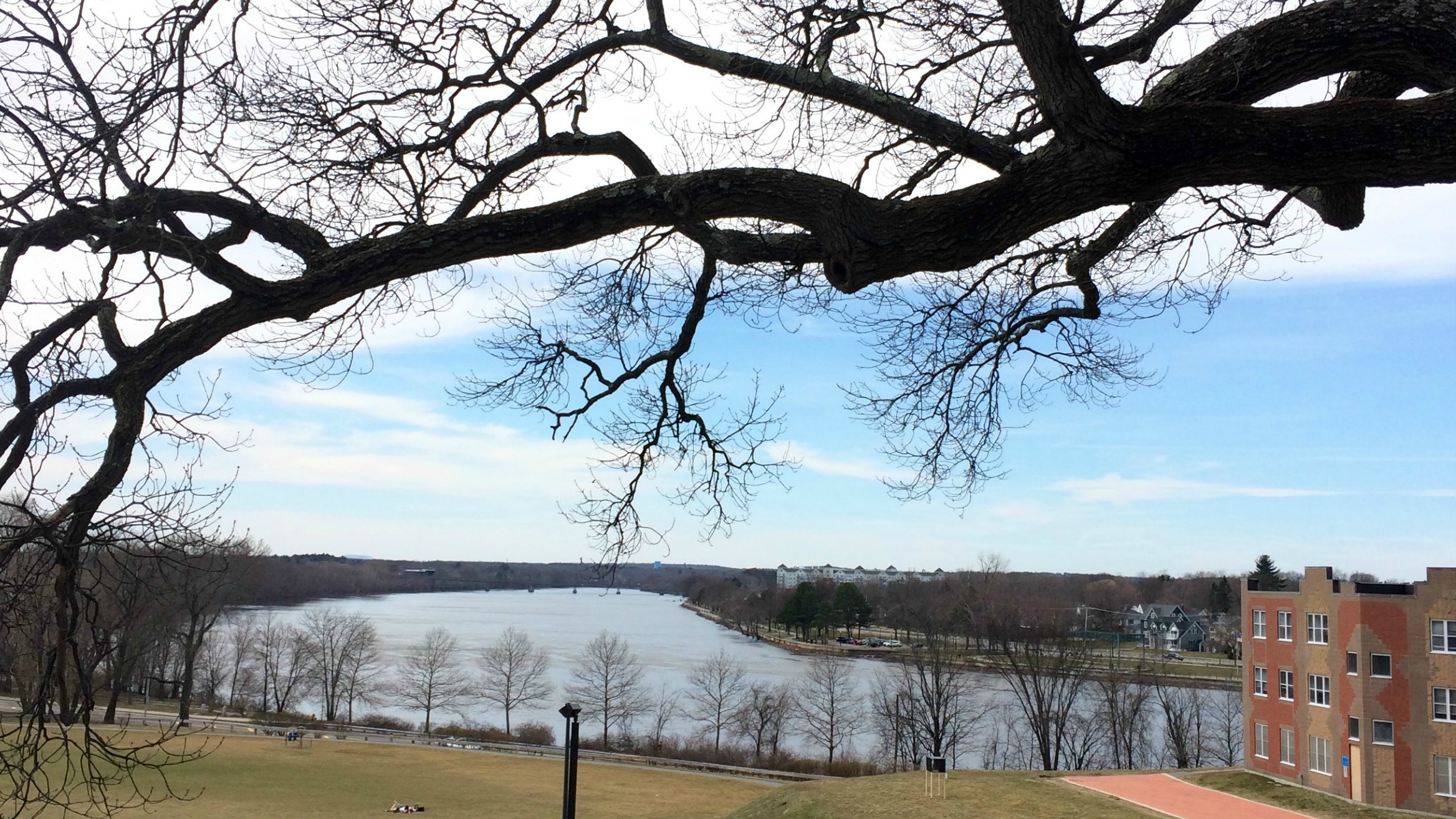
7. Robinson Middle School Parking Lot
Like the Christian Hill Reservoir, the Robinson Middle School is located in Centralville and is also a high point in Lowell. For this reason, the school's parking lot is a convenient and popular destination for viewing the 4th of July fireworks over the river below.
Looking out at the horizon, the entire city can be seen in all directions, as well as Dracut, Tewksbury and the Lowell-Dracut-Tyngsboro State Forest.
8. UMass Lowell's South Campus
Behind UMass Lowell's South Campus's Allen House lies a gently-sloping hill leading to a softball field, basketball courts and larger green space. This spot, surrounded by trees and overlooking the softball field with the Merrimack River in the near distance, provides a very peaceful view.

9. Merrimack River Rapids from the Howe Bridge
The Merrimack River rapids run between the Pawtucket Dam and Beaver Brook. The Howe Bridge (University Avenue) provides a high observation point both upriver towards the dam and down river towards the brook.
Nearby is a small veteran's memorial park with benches and a railing separating the landing from the drop below. It's a great place to view the river and see how the river splits Pawtucketville, directly across the water, and Centralville, further downstream, from the rest of Lowell. University Avenue and the nearby park are also great spots to watch the spring waters roar over bedrock and to catch sight of ducks, geese, herons and other waterfowl as they fly over the bridge.

Lowell Cemetery Inside View (photo thanks to Wikipedia user Emw, some rights reserved).
10. Lowell Cemetery
Lowell Cemetery is a destination for those seeking natural tranquility and serenity. The cemetery - established in 1841 - is centered on a parklike setting in the Belvidere neighborhood. Rolling hills, bright greens and mature trees blend beautifully with ornate, elegant tombstones.
The Lowell Cemetery provides many ways to experience and learn about Lowell through the natural setting, rich history and public art unique to those who are remembered here.
##
Written by Henry St. Pierre
The Lowell Ultimate Neighborhood Guide
Lowell's neighborhoods are a diverse reflection of the city's many populations, each with its own character and history. The eight distinct neighborhoods include: Pawtucketville, Centralville, Highlands, The Acre, Downtown, Back Central, South Lowell and Belvidere.
Some maps also break the neighborhoods down even further to include Lower Belvidere, the upper and lower Highlands and Ayres City, but this guide will focus on the distinct eight.

#Pawtucketville
Pawtucketville is the largest of Lowell's neighborhoods. Occupying the city's northwest area north of the Merrimack River, the neighborhood is mainly residential with lots of open space, parks and other green places for leisure and recreation.
Pawtucketville is an attractive summer destination in the city because of its location along the Merrimack River. Visitors can swim, kayak, fish and even take boat tours along the river. Parks such as the Vandenberg Esplanade and Lowell Heritage State Park are perfect places for summer activities. The Lowell Tyngsboro Dracut State Forest provides an environment for quiet hikes, birdwatching and crosscountry skiing. Other parks in the neighborhood include the Gannon Family Memorial Park, Father Maguire Playground, Fels Park and the Flaggy Meadows Playground.
Also located in Pawtucketville is the historic Hawk Valley Farm on Varnum Avenue. Hawk Valley Farm has been connected to the Varnum family since the 1660s. Today, the grounds still feature the old Varnum House from the 1700s along with various ruins and foundations from centuries past. Hawk Valley Farm is part of an urban land trust that preserves green space in the city to educate visitors of the now urban area's agricultural past.
Other attractions include UMass Lowell's North Campus with its Lydon Library, Costello Center and the Cushing Field Complex.

#Centralville
In Lowell's northeastern corner is the Centralville neighborhood. Separated from Pawtucketville to the west by Beaver Brook and with the Merrimack River along its southern border, Centralville is also a highly residential neighborhood with acres of green space.
The McPherson Playground, with basketball and tennis courts, baseball diamonds and pool is the perfect play area for recreational sports. Another large park, Gage Field, is located across the street behind the Robinson Middle School.
The Robinson Middle School parking lot and the Christian Hill Reservoir are two high points with great vistas of the city and are ideal for stargazing, appreciating city vistas and enjoying Lowell's 4th of July fireworks. Riverfront Park runs along the neighborhood's southern border. The park features the Merrimack River Bike Path, a river level, paved path from Beaver Brook to Duck Island. The park is a great area for summer picnics, jogging, fishing, and spotting hawks, herons, eagles and other wildlife.

#Highlands
Lowell's Highlands neighborhood is situated in the southwest section of the city. At the neighborhood's northern point is UMass Lowell's South Campus. The neighborhood's central section is mainly residential, and the diversity of the neighborhood is indicative of the city's overall culture. Much like Pawtucketville and Centralville, the Highlands features green spaces
and parks. Two active parks are Hadley and Callery Parks.
The Merrimack River serves as the neighborhood's northern border. Its riverfront, directly across the street from UMass Lowell's South Campus, is a scenic area for UMass Lowell students, locals and tourists and is a great place for fishing, picnics and relaxation.

#The Acre
The Acre is a neighborhood west of Downtown Lowell. It is a small neighborhood but is full of vibrancy and activity. The neighborhood is densely populated with a blend of small businesses.
North Common, the Acre's largest park located in the middle of the neighborhood, is an oasis from the urban landscape. North Common includes a public pool as well as basketball courts, making the park a summer destination that is relatively close to downtown.
Western Avenue Studios and Lofts anchor the southwest corner of the neighborhood with over 300 working artists at the studios. Decatur Way is a public, outdoor art space where local art is featured and runs between Merrimack and Salem Street from University Crossing to the LHA's Mercier Center.
#Downtown
Downtown Lowell is full of activity and nightlife as well as unique small businesses and restaurants, each lending its individual flair and personality to Lowell's downtown scene.
Downtown includes: The Tsongas Center, Lowell National Historical Park, Boott Cotton Mills Museum, New England Quilt Museum, Pollard Memorial Library and Lowell City Hall as well as historic canals, such as the Eastern Canal and Upper Pawtucket Canal, and numerous businesses, restaurants and cafés. Check out Lowell's downtown restaurants and cafes here.
Another fun feature of Downtown Lowell is its extensive trolley system. Trolleys are operated by the Lowell National Historical Park and run from spring through fall.

#Back Central
Back Central is located south of Downtown Lowell. It holds the distinction of being the smallest of Lowell's neighborhoods however Back Central has an exciting mix of businesses and residences. A noteworthy feature of Back Central is South Common, a large park located
at the corner of Highland and Thorndike Streets.
#South Lowell
South Lowell, an area also known as Ayres City, is a residential neighborhood that features three large cemeteries at its center. The cemeteries are Westlawn Cemetery, Edson Cemetery and St. Patrick's Cemetery. Surrounding these three cemeteries are many residential roads.
The Concord River flows through the neighborhood and provides a scenic location for nature lovers and relaxation seekers. Muldoon Park features a boat launching spot on the Concord River.

#Belvidere
The Belvidere neighborhood, along with Lower Belvidere, is situated in the southeast corner of the city. The neighborhood is the secondlargest of Lowell's distinct eight. Belvidere is separated from the rest of Lowell by the Merrimack and Concord Rivers.
In Lower Belvidere is the historic Lowell Cemetery, known for its green space and natural serenity. The cemetery features ornate headstones in a parklike landscape, making it a beautiful destination that functions as a public art display surrounded by nature. It was added to the National Register of Historic Places in 1998.
Belvidere also features more green space and parks. Rogers Fort Hill Park and Shedd Park are perfect relaxation spots. The Wyman Bird Sanctuary.
##
Written by Henry St. Pierre